It had bothered Tiger Mann pretty much from the time he started working with New Canaan’s Department of Public Works, as a senior engineer in 1999.
It came on his radar again years later, as the DPW set about dressing up the “gateways” into town.
The town has a conceptual plan to replace it, though funding—as well as state approval—still must be had to see that plan through.
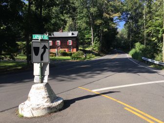
No one knows just when the large concrete structure along Route 106, with the “Stay Right” indicator and Lapham Road sign, showed up in New Canaan. Credit: Michael Dinan
“While I won’t call it ‘iconic,’ it’s been here forever and it’s not the nicest looking thing,” Mann, now public works director, said on a recent morning of the painted white concrete block at Old Stamford and Lapham Roads.
Listing, immoveable, and shaped as though it had been a mooring, the structure has functioned for decades—and not very well—as a traffic island along a major state road into New Canaan. Yet no one seems to know when it got here or whether it had served some practical purpose in a former life.
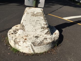
A closer look at this thing. There are no markings on it. Credit: Michael Dinan
It sits in the state right-of-way, though officials with the Connecticut Department of Transportation also have scant information on the structure.
According to the department’s director of communications, Judd Everhart, “this ‘object’ has been here since at least 1985, but not before 1965, according to a photo we have of the intersection from that year.”
“The town would need to submit an Encroachment Permit application with their proposal for the intersection. We would review their proposal as part of the normal Encroachment Permit Review process—that’s when the investigation of the concrete object would normally occur.”
Mann’s plan for a replacement traffic island would be a longer barrier that pointed at a 90-degree angle from Lapham toward Route 106, requiring southbound traffic on the state road to come to a stop (or near-stop, perhaps) prior to turning left.
As it is now, southbound motorists sometimes turn left too soon as they approach the concrete structure, keeping it on their right and veering into the oncoming traffic lane on Lapham, Mann said.
“It happened to me last week, as a matter of fact,” he said.
Mann has put together three options for traffic islands, should New Canaan move forward with a replacement project. One of them, an 18-inch “Field Stone Island,” includes a foundation stone or concrete footing with cap stone and a maximum planting height of 30 inches, to preserve the line-of-sight for passenger vehicles.
A “Granite Island” option includes a concrete footing and backfill and granite curb, and a “Precast Concrete Island” option includes barrier curbing and a maximum planting height of 18 inches.
The intersection has a special place in New Canaan’s history. Locals may not know that Lapham Road actually represents an extension of Old Stamford Road that predates—and predates by more than a century—the stretch that runs down beneath the battered railroad gantry, to the bottom of Weed Street.
According to a street name database that pulls from New Canaan Historical Society records, Old Stamford Road begins at Bank Street as part of the ancient “path that goeth to meet the Perambulation Line”—the original border between Stamford and Norwalk, prior to New Canaan’s incorporation, the traces of which still may be seen throughout town—with the extension to present-day Lapham Road laid out by Stamford in 1700.
The stretch leading to the junction with Weed Street was laid out in 1834, according to Historical Society records, in order to “connect Lapham Road with the old road continuing south from the present end of Weed Street (then called the road to Ridgefield).”
After that connection was made, the whole road was called “Stamford Avenue”—a name changed in 1935 to Old Stamford Road, records show.
Once created, the carefully planted traffic islands in town often are maintained by “adopting” members of the venerable New Canaan Beautification League.
Asked about the intersection, NCBL member Faith Kerchoff said Lapham and Old Stamford Roads is one of three being looked at now for improved safety and traffic flow. The other prospective traffic islands are for Canoe Hill and Laurel Roads, and Ponus Ridge and Greenley Road. The newest triangle that the Beautification League helps out with is in front of the Thrift Shop downtown, she said.
Prior to going to the state, Mann said, the new plan for a proper traffic island would need approvals from the New Canaan Traffic Calming Work Group and then Police Commission.
Its been there since the 60’s. I was born in 1962 and it has been there for my entire life. I now live in Wilton but spent 39 of my 55 in New Canaan.
Rt. 106 with 90 degree turn also poses a major safety factor for house driveway access at and near intersection with Lapham as cars come speeding around curve. A traffic light is the safe alternative with signs for cars to slow down for traffic light. Also a major problem for school bus drop off of children. Neighbors are also deeply upset and prepared to challenge proposal for cell tower near intersection adding to frustration.
It dose the job – No need to waste tax money on this project – give it a paint job and call it a day.
This is not ideal as an object, but there are many incremental less-costly options that include paint on the roadway and lower cost posts that could reduce accidents.
The intersection approximately 1 mile north, where Park St and 106 intersect is much more highly trafficked. Tiger was part of an initiative and plan to correct that turn 5 years ago that died due to funding. Accidents there included a boy being hit by a turning left at full speed onto park st.
The house in the background was purchased by our family in or around 1960 and the “round about” wasn’t there at that time. While we lived in the house at 399 Old Stamford Rd, we were witness to many severe, head-on traffic accidents on that corner of Rt. 106 and the intersection of Lapham Hill Rd. The driver of a 106 southbound vehicle wanting to go up Lapham Hill Rd would, without the “round-about” in place at that time, treat the intersection as just a fork in the road and would “shoot” across the northbound lane. The oncoming northbound traffic was unable to see the southbound vehicle around the corner and the other vehicle in time to avoid the crash. All too frequently we were witness to devastating head on accidents involving vehicles at speed. I’m guessing that the “round-about” was installed in or around 1968 and, this installation did eliminate accidents around this corner as the vehicles wanting to go up Lapham Hill Rd. were directed to “stay right” and had to slow down to do so.
The “round-about” may need paint now but as one who lived on that corner until 1974 I can tell you that it was, and probably still is necessary and effective. Feel free to contact me if you wish to discuss.