Officials Ponder Safe Pedestrian Route to Main Street Sidewalk from Down River Road

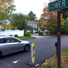
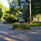
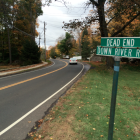
Town officials are trying to figure out a safe way for residents on Down River Road to hook up with the Main Street sidewalk, providing a route to the village center. The first step, according to Tiger Mann, assistant director of the New Canaan Department of Public Works, is to see if there’s a way to get those pedestrians at least as far as the treatment plant driveway—just halfway to a crosswalk at Harrison but at least clear of the blind curve north of Woodland. Michael Stayman of 36 Down River Road, one of nine homes on the street, told Mann and other members of the Traffic Calming Work Group at their most recent meeting that as of now, residents are taking their lives into their hands by running across to the sidewalk on the west side of Main right at Down River Road. “We don’t have any other way because the road is on the opposite side of Main Street from the sidewalk,” Stayman said at the meeting, held Oct. 14 in the training room at the New Canaan Police Department.

Old Studio Road at 106: ‘The Crosswalks That Lead to Nowhere’

Prompted by a request for a crossing guard that would help get kids cross Route 106/Old Stamford Road from the area of Old Studio Road, toward South, Saxe and the high school, town officials are trying to answer a bigger question about how whether there’s a way to create a safe pedestrian walkway along that stretch of Route 106 itself. The difficulty is that, although there are crosswalks there—for example, at the southern end of the Old Studio Road horseshoe—there’s no safe route for pedestrians once they’ve landed on the eastern side of the state road. “They are kind of crosswalks that lead to nowhere,” New Canaan Police Capt. John DiFederico said Tuesday during a meeting of the Traffic Calming Work Group. Composed of police, fire, CERT/emergency preparedness and DPW officials, the work group fields requests for traffic calming measures. At least one parent from the west side of Route 106 there (Old Studio Road, Richards Lane) and South School officials had inquired about the possibility of putting in a crossing guard at the crosswalks, DiFederico said.

After Resident Petition, Town Eyes Traffic-Calming on Parade Hill Road

Town officials are collecting data on cars’ speeds on Parade Hill Road and plan to enforce selectively the 25 mph limit there after residents said that pedestrians, bicyclists and drivers are at risk because trucks and other motorists travel and take blind turns too fast. Parade Hill is a popular cut-through between Routes 124 (Oenoke Ridge Road) and 123, including for commercial traffic on Interstate 95. Residents this spring petitioned the town to slow down the vehicles that use it. On Tuesday, members of the Traffic Calming Work Group agreed to put up speed sentries and, with hard data in hand, selectively enforce the 25 mph speed limit there. Parade Hill Road resident Mary Maechling said vehicular traffic seems to be getting increasingly fast, especially on weekdays, and that she sees many near-misses up near a blind curve toward the top of the road.

Town Weighs Fix for Awkward Traffic Island at Canoe Hill and Laurel

If the geometry works, town officials may recommend enlarging the traffic island where Canoe Hill and Laurel Roads meet, so as to avoid confusion about what path cars should take, and when. Signs posted on the small island instruct motorists to stay to the right, and those coming from Laurel Road must yield. As it is, motorists traveling down (east, toward 123) Canoe Hill face the non-intuitive prospect of going around the traffic island, which sweeps cars slightly to the right (toward Laurel) in order to continue on that road, which then jogs left. The road also feels wide enough to motorists on that approach that it should accommodate two-way traffic on the left-hand side of the island. “It’s just unnatural to go around it, the way it is,” Police Capt. John DiFederico said Tuesday at a meeting of the Traffic Calming Work Group.