Now & Then: Henry B. Rogers House
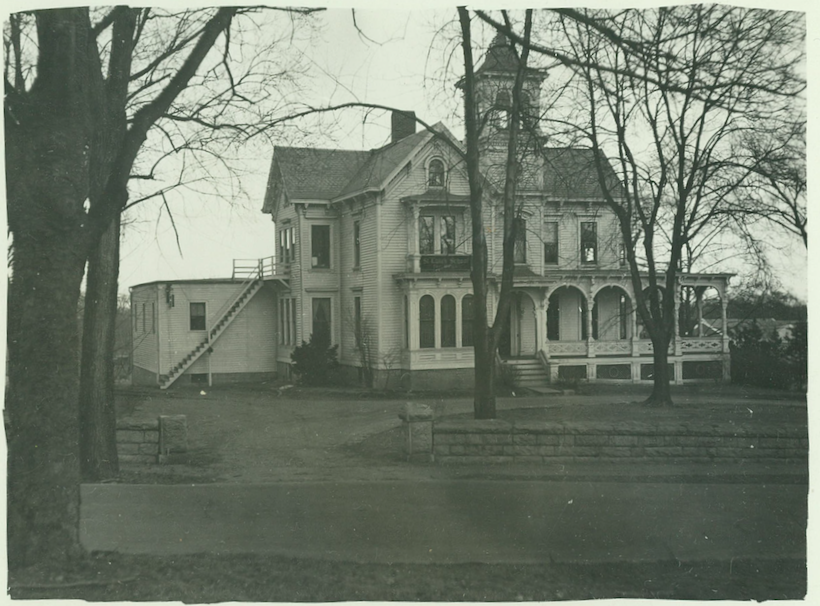
Henry B. Rogers built 62 Park Street in the 1870s (photo above is ca. 1930s).
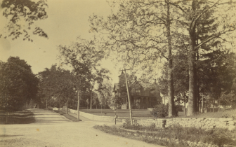
Looking at the Henry B. Rogers House from Elm and Parks Streets, ca. 1910. Photo courtesy of the New Canaan Museum & Historical Society
It was one of the few mansions in the center of town and, like many, is now a parking lot. Rogers’ success came from the shirt manufacturing business he established with another New Canaan resident Albert B. Comstock. Originally called Comstock, Rogers & Co, the company name was changed in 1878 to Henry B. Rogers & Co. when Comstock sold his interest in the company to Rogers. At this same time, a pictorial map shows thatthe company was located in what is now 56 Main Street, the building next to the New Canaan Thrift Shop.
Much like the shoe factories in town, the majority of the work was not actually done at the factory. Rather, the cloth was cut into patterns and then distributed to workers, mostly women, to take home and sew together. The workers then brought the clothes back to the factory for finish work. Workers were paid on the number of pieces they sewed together.
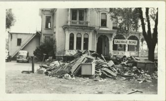
The Henry B. Rogers House property was used as a Salvage Depot as part of the World War II effort. Photo ca. 1940s courtesy of the New Canaan Museum & Historical Society
The business seems to have done very well because in 1883 Rogers constructed 86-92 Main Street. The business was also doing well enough that in 1881 Rogers was one of the first four people in New Canaan to own a telephone. It is not clear if the line was installed at his house or the business, but it was most likely for the business. 86-92 Main remained the Henry B. Rogers & Co. until Rogers retired
from the business in 1903.
The Rogers family sold the house in 1914 to Fred Ruscoe who rented out the property for about a decade. In 1923, there was talk of turning the property into a community center. These plans fell through but probably inspired the creation of the “Tom Thumb Golf Course,” a miniature golf course, probably the first and only mini golf course in New Canaan’s history, that was on the property in the early 1930s.
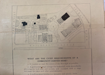
An old schematic for a proposed community center in the area of what is today the Park Street Lot. Image courtesy of the New Canaan Museum & Historical Society
In the later half of the 1930s, the house became the first location of St. Luke’s School. This, however, was not the first school on this property. New Canaan’s first school was built on this location in 1816 and remained open until 1834. Never a community to waste a good structure, the school building was then moved to the north corner of Cherry and Main streets, where it remained until 1936 when it was torn down.
Throughout World War II, the building was occupied by the American Legion. The front lawn served as the salvage depot for all the materials that could be reused in the war effort. Eventually in 1944, the Rogers’ house was purchased by the town for $15780.13 for the express purpose of turning the property into a parking lot. At this point the building was in poor shape and was torn down sometime in the first half of 1945.
“New Canaan Now & Then” is presented in partnership with the New Canaan Museum & Historical Society.

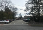
Note that the wall outside the parking lot is original!!!
The 1910 picture taken from Park & Elm puzzles me. It shows totally flat land, like Ohio/Indiana. Where’s the hill? Google Maps shows #62 Park St is the municipal parking lot across from the Bergmann house, near the top of the hill. It should be about 1-2 stories higher than the intersection of Park & Elm.
Barbara you raise a really good question. We discussed this at length at the Historical Society. Here’s what’s written on the back of the photo: “Park & Elm intersection looking north ca. 1910.” There are a few possibilities. One is that the photo itself is a little deceiving. You can see that there’s a climb/hill/change in grade from where the photographer is standing, all along the right side of what the photo ID’s as Park Street, though it may be more extreme than it appears to us in the photo due to the position of the photographer and angle of the camera. It’s also possible that the photographer is standing at Park and Elm—so the present-day white brick building we know as the former Brotherhood & Higley offices would be on the immediate right in this frame, and the street that’s coming across the photo is not Elm Street itself but something like the alley that runs off of Park and parallel to Elm Street as we know it today. Also, sometimes there are changes to the exact boundaries of a road—they sometimes are shifted or widened, for example—as well as changes in the grades of roads over time, due to updates to infrastructure such as sewer and drainage systems. We also speculated that the photo actually could be taken from Elm Street facing west, and that the road that’s cutting across the photo L-R would be in the area of the alley beside where present-day Chef Luis is located, but that seems unlikely. Unfortunately, it’s not easy to say in that particular photo which side of the house is facing in what direction, it’s just a bit too far away.
Looking at the picture blown up and the distances, I think it might have been taken from Pine/Cherry and Park intersection and not Elm and Park. There is a slight incline first (where CVS/Toy Store are) then you can see the larger hill up to God’s Acre further back.
The house just looks too far away for this to be taken from Elm and Park.
That’s very possible, and the photographer very likely would have been standing on Park roughly across from where present-day CVS is located, because Pine Street originally did not run straight toward Cherry as we know it today. It jogged left/north as it ran east toward Park Street at that end.
Could be. The near-right side of the photo (where the Melba Inn would eventually stand) has the necessary elevation.